Ravi V. S. Kanda Research
Lithospheric Dynamics
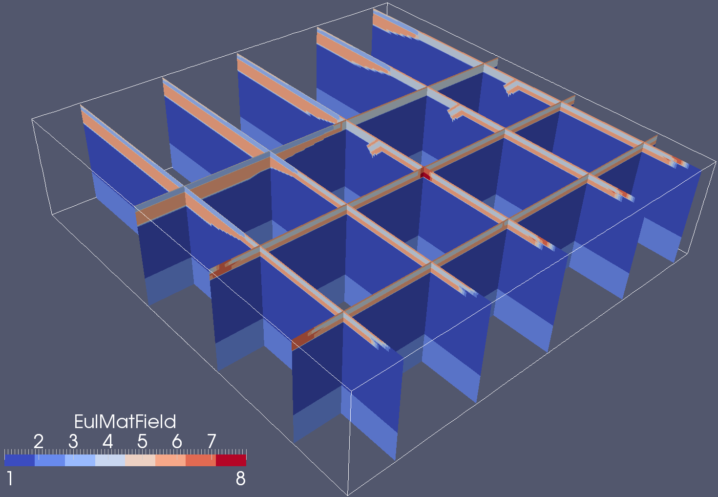
4D lithospheric dynamics simulations
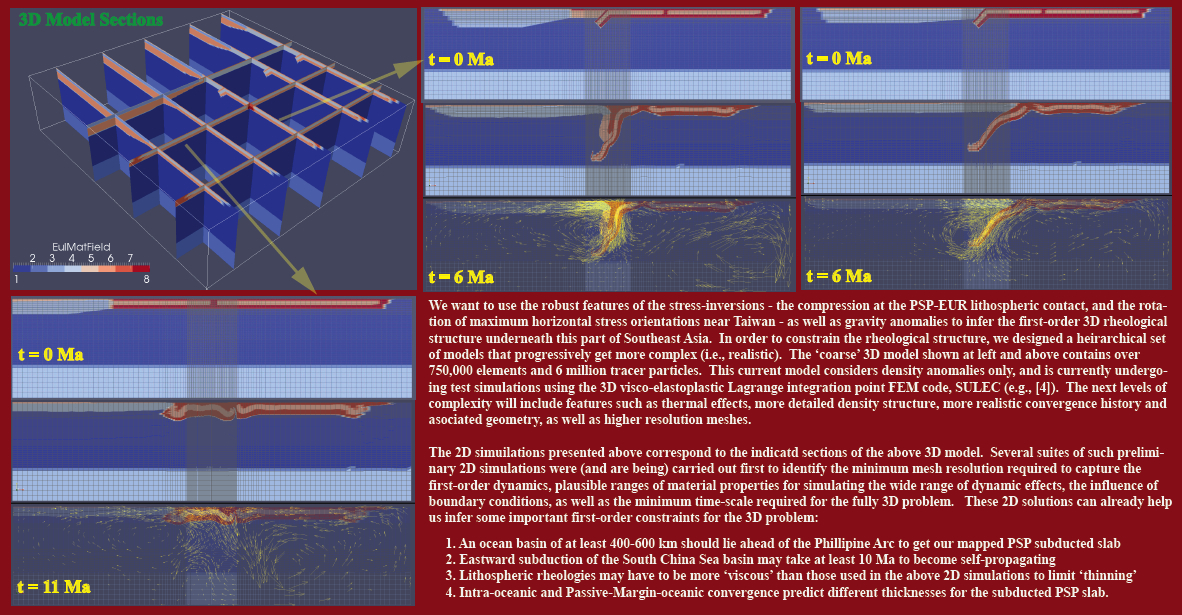
Oblique convergence between the Luzon arc on the Philippine Sea plate (PSP) and the Eurasian continental margin is associated with a progressive termination of northwestward collision in northern Taiwan along with the eastward subduction of the Eurasian plate underneath the island. It has long been recognized that one model for this flipping of subduction polarity beneath Taiwan is the progressive tearing of the Eurasian plate along the continental margin. Modern global tomography, combined with local tomography near Taiwan images this predicted torn northern edge of the Eurasian slab within the continental mantle lithosphere, which is subducting underneath the collisional mountain belt as a single slab that is continuous with the subducting oceanic lithosphere of the South China Sea. Seismic observations also indicate that the subducting Philippine Sea plate experiences east-west compression – as well as horizontal flexure – at depths shallower than 100 km near its orthogonal contact with the Eurasian lithosphere. Here, we make a first attempt to understand the complex 3D plate interactions associated with the PSP-Eurasia convergence, and to evaluate the role of slab versus mantle driving forces in its evolution. Specifically, we aim to understand the relatively recent change in PSP motion that initiated the deformation of the Eurasian margin and the formation of Taiwan. Unfolding of tomographically inferred present-day subducted slab geometries surrounding the PSP provides kinematic constrains on its interactions with adjacent plates over the past 10s of Ma. The resulting relative plate motions provide the driving boundary conditions for our forward numerical models of lithospheric dynamics, thus allowing us to test new regional plate-tectonic hypotheses. We are exploring a hierarchical set of models with increasing complexity to investigate the sensitivity of model predictions to boundary conditions as well as upper-mantle and slab rheology. Our simulations can be verified by comparing with both kinematic (e.g., geodetic velocities, plate convergence rates) and dynamic (e.g, gravity, principal stress ellipsoids, exhumation rates) observations of the 'present-day' deformation field. Our ultimate goal is to infer the large-scale rheological structure of the lithosphere and the mantle across this region of orthogonal subduction beneath northern Taiwan.
- Kanda, R. V. S., J. Suppe, S. M. Ellis, S. Buiter (2012), 3D Numerical Models of Slab-Mantle Interactions: Implications for Eurasia Philippine Sea Arc-Continent Collision, EOS Trans AGU, 93, Fall Meet. Suppl., Abstract T43F-2739.
- Kanda, R. V. S., J. Suppe, S. M. Ellis, Y.-J. Hsu, Y.-M. Wu (2011), Relative Dynamic Strengths Of Orthogonally Subducting Slabs Under Taiwan, EOS Trans AGU, 92, Fall Meet. Suppl., Abstract T51A-2313.
3D/4D Geophysical & Geological constraints for lithospheric dynamics
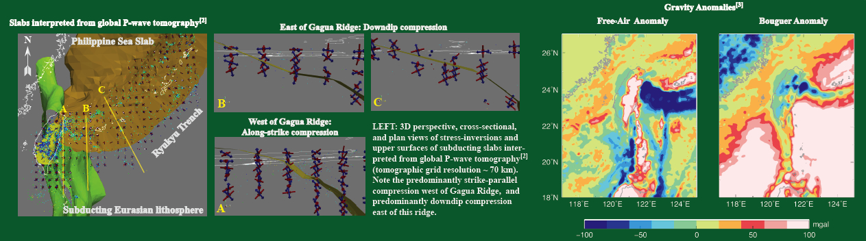
In order to explain the observed present-day deformation field using numerical models for lithospheric dyanmics, we need both kinematic (e.g., geodetic velocities, plate convergence rates) and dynamic (e.g, principal stress ellipsoids and their orientations) constraints. A major part of my work in Taiwan so far involves developing such regional 3D constraints. I wrote portable open-source software to help our research group visualize and unfold subducted slab geometries illuminated by global tomography within a spherical Earth. Using this software, together with the publicly available plate reconstruction package, GPlates, allows us to reconstruct the complex plate-motions in Southeast Asia over the past 100 Ma. For constraining present-day model stresses in the lithosphere and uppermost mantle, I developed new 3D maps of focal-mechanism based principal-stress orientations for the PSP. Additional constraints come from high-resolution regional gravity and magnetic anomalies. I am trying to infer robust features of the 3D stress-field over the northern and western edges of the Philippine Sea plate - shallower than 120 km - based on the most current focal mechanism dataset for earthquakes beneath Taiwan and the Ryukyu Arc. While previous studies based on earthquake locations and focal mechanims have looked at either the southwestern corner of the Ryukyu Arc or only the Eurasian crust, here we want to infer the stress field both within the flat and subducting portions of the PSP, as well as at sub-crustal depths within the subducting Eurasian Plate. As a first attempt, I explored the stress-field (principal stress orientations and relative magnitudes) over the northwestern PSP at three different spatial resolutions, in order to identify its scale-independent characteristics. Resolution of such scale-independent features of the stress-field can provide important insights into regional lithospheric dynamics.
- [In Prep.] Kanda, R. V. S., Suppe, J., Y.-J. Hsu, Y.-M. Wu, High resolution 3D seismic, geodetic, structural, and gravity constraints for lithospheric dynamics in the vicinity of the ongoing Taiwan arc-continent collision.
- Suppe, J., R. V. S. Kanda, Y.-M. Wu (2012), The 3D lithospheric structure and plate tectonics of the on-going Taiwan arc-continent collision and delamination: a context for understanding patterns of geomorphic uplift and contemporary stress and geodetic displacement fields, EOS Trans AGU, 93, Fall Meet. Suppl., Abstract T41E-05.
- Wu, J.E., J. Suppe, R. V. S. Kanda (2012), Cenozoic East Asia plate tectonic reconstructions using constraints of mapped and unfolded slabs from mantle seismic tomography, EOS Trans AGU, 93, Fall Meet. Suppl., Abstract T41F-07.
- C. D. Lin, J. E. Wu, J. Suppe, R. V. S. Kanda* (2012), The trajectory of India towards Eurasia recorded by subducted slabs: implications for the fate of NeoTethys, EOS Trans AGU, 93, Fall Meet. Suppl., Abstract T41C-2602.
[ * MY NAME APPEARED IN THE POSTER PRESENTATION, BUT NOT IN THE AGU ABSTRACT BY MISTAKE]
Thermal modeling of crustal deformation
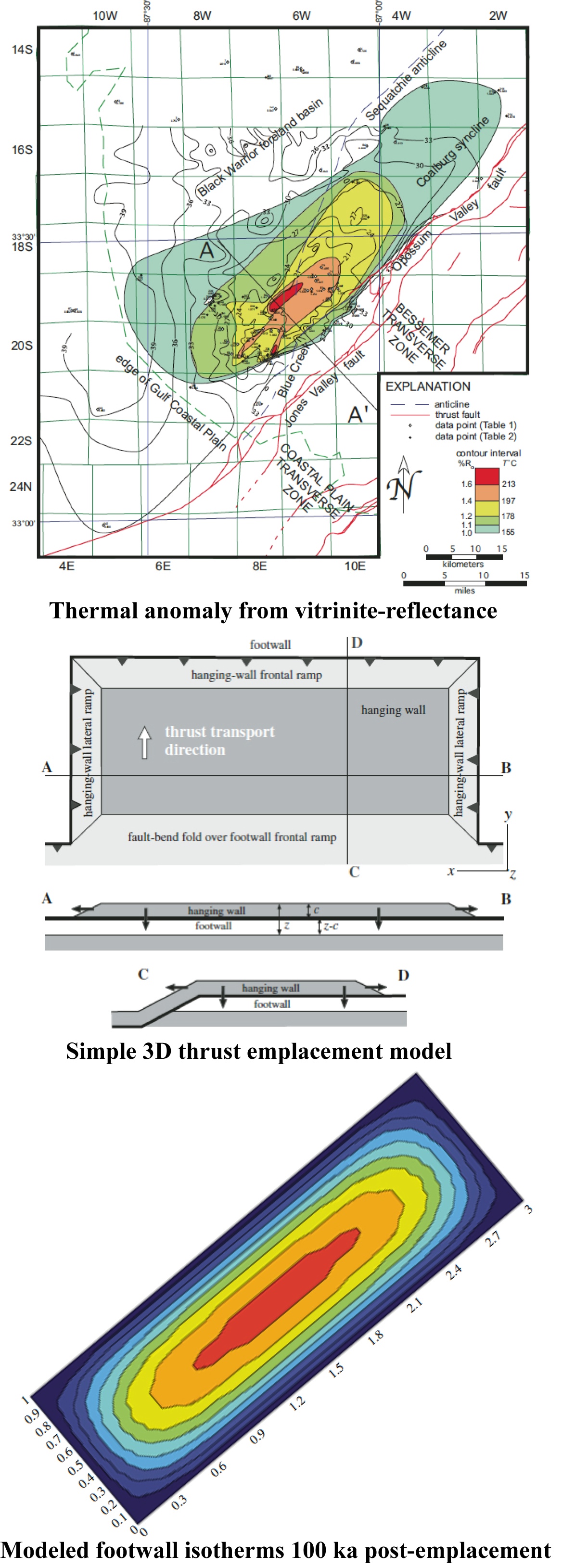
Erosion of the leading hanging-wall cutoffs of thrust sheets commonly obscures the magnitude of thrusting. The Jones Valley thrust fault in the southern Appalachian thrust belt in Alabama, USA, is exposed along a northwest-directed, large-scale frontal ramp, and the leading part of the thrust sheet has been eroded. Previously published and newly collected vitrinite refl ectance data from Pennsylvanian coal beds document a distinct, northeast-trending, elongate, ovalshaped thermal anomaly northwest of the trace of the Jones Valley fault. The northwest edge of the thermal anomaly is ~18 km northwest of the fault trace, suggesting the original extent of the eroded thrust sheet. The anomaly ends both northeastward and southwestward along strike at lateral ramps. The southeast edge of the anomaly corresponds to the location of a footwall frontal ramp.
A three-dimensional heat conduction model for simultaneous horizontal (twodimensional) and vertical heat fl ow in a rectangular thrust sheet is designed to test whether the documented thermal anomaly (%Ro = 1.0–1.6) may refl ect the former extent of thrust-sheet cover. The model uses a 3-km-thick thrust sheet with horizontal dimensions of 10 × 30 km, as well as a threedimensional analytical solution to the heat conduction equation, whereby the thrust sheet cools both laterally and vertically. The model reproduces the magnitude and oval shape of the vitrinite refl ectance anomaly at 100–500 k.y. after thrust emplacement. The geothermal gradient reaches a steady state at ~2 m.y., and is never fully reestablished even for long times because of lateral cooling in the hanging wall. Thickness and extent of the thrust sheet from the thermal model are consistent with balanced and restored cross sections of the Jones Valley thrust sheet based on geologic data; a thrust sheet ~3 km thick was emplaced ~18 km onto the foreland over the site of the thermal anomaly. The three dimensional thermal evolution of both the hanging wall and the footwall is distinct from that predicted from one-dimensional models; a three-dimensional model predicts less heating of the footwall because of horizontal heat loss across bounding ramps.
![[PDF]](../images/pdfico.png) Thomas, W. A., R. V. S. Kanda, K. D. O'Hara, D. M. Surles (2008), Thermal footprint of an eroded thrust sheet in the Southern Appalachian Thrust Belt, Alabama, USA, Geosphere, 4(5), p. 814-818, doi 10.1130/GES00168.1.
Thomas, W. A., R. V. S. Kanda, K. D. O'Hara, D. M. Surles (2008), Thermal footprint of an eroded thrust sheet in the Southern Appalachian Thrust Belt, Alabama, USA, Geosphere, 4(5), p. 814-818, doi 10.1130/GES00168.1.
- K. D. O'Hara, R. V. S. Kanda, and Thomas, W. A.(2006), Thermal Footprint of an Eroded Thrust Sheet in the Black Warrior Basin, Alabama, USA, GSA Abstracts with Programs, Vol. 38, No. 3, Abstract 101868.